Projects
Recent Projects
Pescadero-Butano Creek Watershed Sediment Source and Delivery Analysis
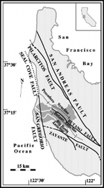
Pescadero-Butano Creek Watershed Sediment Source and Delivery Analysis, San Mateo County, California: Assessment of Historical Channel, Floodplain, and Estuarine Changes, Sediment Delivery, and Sediment Yield.
Memorandum prepared for San Francisco Bay Regional Water Quality Control Board, on behalf of University of California, Berkeley, to inform Pescadero-Butano Creek Watershed Sediment TMDL and Salmonid Population Dynamics Modeling Study. 136 pages.
Since the end of the Mexican-American War and California’s admission to the United States, as well as the arrival of Euro-American and European settlers (in about 1850 and 1860, respectively), the 208.4-km2 (80.5 mi2 or 51,500 acres) Pescadero-Butano Creek Watershed has experienced the widespread extraction of its natural resources, notably fish, terrestrial wildlife, timber, water, ore minerals, and oil and gas over about 70% of its landscape. The agricultural activities (ranching, dairy farming, dryland farming, and industrialized farming) have been taking place over an area of 11,200 acres since 1850 (of this, 3,300 acres were converted from scrublands and 3,900 acres from timberlands in 1850-1970), and the timbering activities took place over an area of 25,500 acres from 1850 to 1970. Since 1970, most of the timberlands were turned into public parks, and the remainder (about 1,000 acres) have experienced sustainable forestry practices.
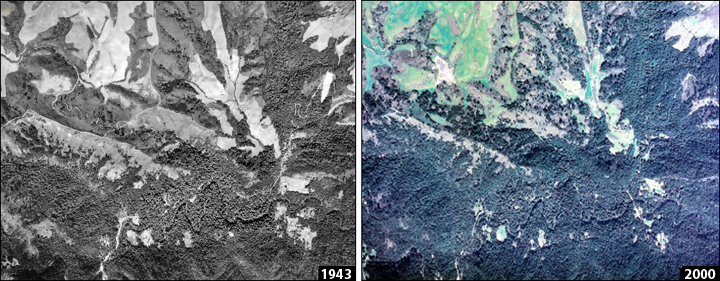
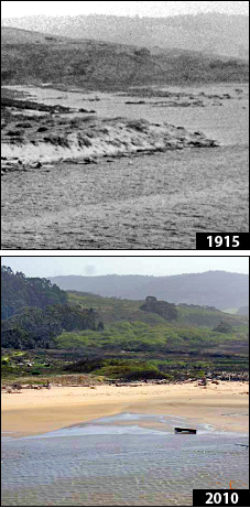
In response to the land-use post-1820, a profound geomorphic transformation took place over the subsequent 190 years across the entire Pescadero-Butano Creek Watershed, its channel network, and its estuary. The majority of the land-use related impacts and the associated geomorphic transformation had already occurred by 1920, including the near elimination of native fish populations by the 1890s. Over the past 100 years, the watershed has been experiencing the cumulative effects of multiple environmental changes associated with particular land-use practices. Many of these cumulative hydrological effects, and the effects of watershed changes on sediment sources and sediment routing along channel networks, are severe and have nearly irreversible impacts. The effects included the following: (1) a 99% loss of flood-prone swampy meadow valley floors by the 1870s and the abandonment of 99% of the natural floodplains by the 1940s, with the associated reduction in riverine winter off-channel (floodplain and/or side channel) rearing habitat for salmonids in low-gradient stream channels; (2) an increase of 100-130% in the total sediment delivery to stream channels across the watershed by the 1890s, including the transformation of long-term geomorphic sediment sink landforms (storing an estimated 99 millions tons of fine-textured and unconsolidated sediment) to sediment sources and the formation of new fine- and coarse-textured unconsolidated land-use-related sediment deposits across the watershed (9 million tons), with the associated degradation of the channel streambed substrate and the quality of the spawning habitat for salmonids (the permanent coarsening of formerly fine-grained substrates within the low-gradient alluvial reaches, and the fining of formerly coarse-grained substrates within the steeper reaches in the uplands); (3) the reduction of the longitudinal and planform channel morphologic and the salmonid habitat complexity—especially involving pools—along stream reaches providing riverine summer rearing habitat, and winter rearing habitat, starting in the 1860s; (4) the severe disturbance of boulder-cobble streambed substrate, known to provide riverine winter rearing habitat for salmonids in steep stream channels in about 30% of the Pescadero-Butano Creek Watershed area, which is underlain by competent, cobble-boulder-substrate producing bedrock (i.e. Mindego Basalt, Vaqueros Sandstone, and Butano Sandstone geologic units), starting in the 1860s in limited areas during the 19th century timbering activities, and in the 1920s across half of the watershed during the 20th century timbering activities; (5) the transformation of the watershed’s deep-water estuary into a shallow creek delta, starting in about 1920, due to the deposition of up to 5.7 millions tons of sediment, and involving a 60% reduction in the size of Pescadero Marsh and a 85% loss of the tidal prism within the lagoon, with the associated adverse effects on the estuarine summer rearing habitat for salmonids; (6) the triggering of legacy sediment sources, namely those of channel incision and hillside gullying, which persistently supply elevated loads of sediment; and (7) frequent flooding within the town of Pescadero since about 1940, most notably since 1990.
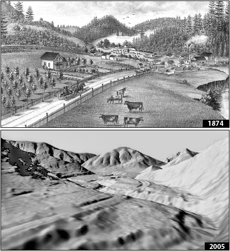
Absent of any sediment management and watershed rehabilitation and/or restoration actions, the ongoing legacy channel incision-turned-widening and hillside gullying processes, as well as the industrialized agricultural activities, are likely to maintain this elevated sediment delivery of 100-130% over the natural background levels across the watershed, as well as sediment delivery to the Pescadero Marsh/Lagoon Complex (including the historic tidal reaches), for decades to come.
Read the Pescadero-Butano Creek Watershed Report by Balance Geo, prepared for the San Francisco Bay Regional Water Quality Control Board, on behalf of Earth and Planetary Science Department, University of California, Berkeley, California
To support the development of a sediment TMDL and an associated salmonid habitat enhancement plan for the Pescadero-Butano Creek watershed, Martin Trso was hired by the San Francisco Bay Regional Water Quality Control Board in 2010 to assess and quantify: (1) the disturbance history (natural geomorphic and anthropogenic land-use) of the Pescadero-Butano Creek watershed, (2) the geomorphic response to natural and land-use related disturbance, including historical channel and floodplain changes, sediment delivery, and sediment yield across the watershed; and (3) the corresponding sediment budgets for the watershed for each distinct geomorphic area and the disturbance period, including the natural reference state. As principal investigator, Martin Trso conducted this geomorphic investigation in association with Prof. William E. Dietrich of the Earth and Planetary Science Department, University of California, Berkeley, who provided technical advisory and peer review of intermediate products during the multiple-year study period.
Specifically, the geomorphic, land-use, and sediment source and delivery assessments in support of the evaluation of the historical channel and floodplain changes, sediment delivery, and sediment yield within the Pescadero-Butano Creek Watershed and the Pescadero Marsh/Lagoon Complex involved the following: (1) the development of hypotheses concerning the natural state of sediment delivery and sediment transport, stream channels, floodplains, Pescadero Marsh/Lagoon Complex, and the pre-1820 locations of rearing and spawning reaches for steelhead trout (Oncorhynchus mykiss) and coho salmon (Oncorhynchus kisutch); (2) the assessment of the watershed’s natural disturbance and land-use history post-1820, in order to frame the sediment budget analysis; (3) the qualitative and quantitative assessment of the geomorphic response to post-1820 natural disturbance and land-use, including the transformation of the channel network, floodplains, and Pescadero Marsh/Lagoon Complex; (4) the collection of field data on stream channel dimensions (bankfull and summer-flow) and channel morphology; (5) sediment source and delivery analysis, involving a) the identification of natural and anthropogenic (land-use) related sediment sources and storage on hillside and along the watercourses, as based on surveys and GIS/DTM modeling, and b) the interpretation of available technical data developed by other consultants, researchers, and agencies; and (6) the construction of closed, process-, causality- and grainsize-specific sediment budgets (sediment delivery, transport, storage, and yield) for the Pescadero Creek Sub-Watershed, Butano Creek Sub-Watershed, and the Pescadero Marsh/Lagoon Complex for the pre-1820 (natural reference), 1820-1920, 1920-1970, 1970-1990, and 1990-2010 periods.
The geomorphic, land-use, and sediment source and delivery assessments built upon the following: (1) the assembling, review, and interpretation of several dozen historical, technical and research documents and reports developed by multiple agencies, inter-disciplinary programs, consultants, contractors, non-profit organizations, and private citizens for this watershed over the past 35 years; (2) the acquisition of historic documents, maps, and ground and aerial photographs spanning the past 240 years; (3) interviews and anecdotal accounts of watershed events and land-use history from private citizens and business owners, many of whom are long-time residents over 85 years of age; (4) extensive field reconnaissance across the Pescadero-Butano Creek Watershed, including numerous private properties and the San Mateo County and State parks; (5) the high-resolution geomorphic mapping of the Holocene alluvial valley floor, the alluvial fan and other natural and land-use related depositional landforms; (6) the delineation of the Quaternary deep-seated bedrock slide terrain; (7) the mapping of planform changes (i.e. channel shifting) along the alluvial-valley reaches of Pescadero and Butano creeks over the past 150 years; (8) the delineations of areas of land-use specific disturbance over the past 190 years; and (9) the development of digital terrain models (DTM), based on San Mateo County’s high-resolution digital elevation model (DEM), of erosion, mass wasting, sediment delivery, and sediment transport and deposition across the Pescadero-Butano Creek Watershed and the Pescadero Marsh/Lagoon Complex.
Pope Creek Quarry Revised / Amended Reclamation Plan
The Pope Creek Quarry in Napa County, California, was opened in the mid-1940s, and involved surface mining for basalt. The quarry facilities are comprised of the hard rock quarry and the batch/wash plant (essentially an aggregate wash pit). The rock processed from this quarry was used for riprap, base rock, and drain rock.
In 2013, following the expiration of the surface mining permit, the facilities were closed and are being reclaimed by the quarry operator Don Wesner, Inc. The reclamation efforts, as specified in the original surface mining permit (Napa County PBES 1998), involve the following at each facility site: (1) the removal of all unused equipment, trash, debris, buildings, and other associated installations; (2) re-grading, re-contouring, and de-compaction of ground areas subject to past quarry related operations; (3) the installation of temporary and permanent erosion, sediment, and runoff control measures and BMPs; and (4) re-vegetation and invasive plant species control. To meet the requirements of the specified end use, and to minimize surface erosion arising from the reclamation re-grading and re-contouring of the sites, each site must be re-vegetated with native plant species. Once reclaimed, both sites will be suitable for open space and wildlife habitat.
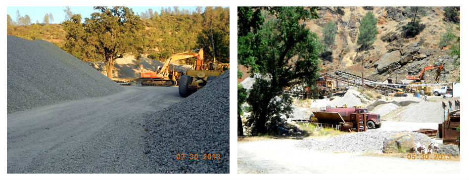
Balance Geo was hired by the quarry operator in 2013 to amend and revise the original reclamation plan, and bring the facilities into compliance with the County and State regulations. The investigation has involved: (1) the assembly and review of all relevant quarry related documents and reports, as well as historical and recent aerial photography; (2) the acquisition and computer processing of the County’s 25-foot digital elevation model (DEM); (3) the ground topographic survey and mapping of the pre-reclamation ground surface topographic conditions; (4) an interview and personal communications with the operator of both quarry facilities; (5) the evaluation of geologic, soil, hydrology, geomorphic conditions, geotechnical slope stability, and earthquake ground motion; (6) the modeling of pre- and post-reclamation stormwater runoff; (7) the re-sizing and design of the pre-existing runoff detention and sediment settling basin at the hard rock quarry site and the aggregate wash pits at the batch/wash plant site (in order to comply with Napa County and State surface mining regulations, stormwater runoff from within the quarry facilities during mining operations had to be adequately contained on-site); (8) computer topographic modeling to design the layout and ground surface topography at each quarry facility under the post-reclamation conditions; (9) the development of site grading and design plan maps for each quarry facility, including the erosion, sediment, and storm runoff control plans; and (10) the development of industrial stormwater pollution prevention plans for each quarry facility. The amended and revised reclamation plan was approved in 2014.
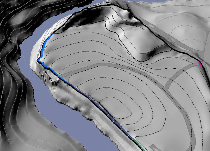
Batch/Wash Plant Post-Reclamation Design Plan Map
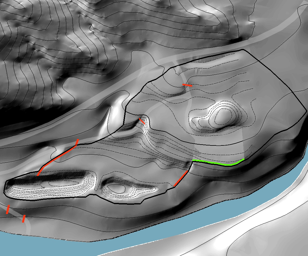
Hard Rock Quarry Post-Reclamation Design Plan Map
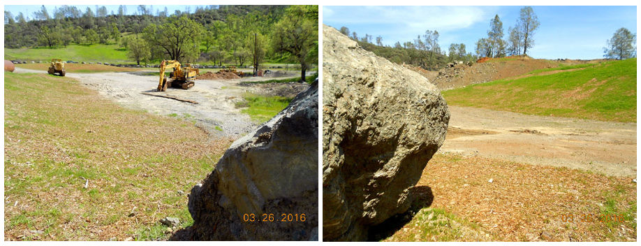
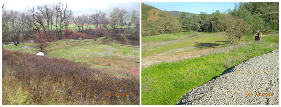
The quarry reclamation efforts have been successful despite water shortage issues caused by the historic drought post-2011. As presented in the site grading and design plans of the revised reclamation plan, the reclamation re-grading and re-contouring at the quarry facility sites have involved extensive grading, smoothing, and void backfilling in the relatively horizontal area stretching between the crescent-shaped knoll in the north of the hard rock quarry and the pre-existing runoff detention and sediment settling basin. This has been coupled with limited grading of the steep side slopes of the knoll, to subtly recline the slopes in order to increase slope stability, and road abandonment across the knoll. An estimated 19,000 cubic yards of original and stockpiled topsoil have been spread over the reclaimed areas at both quarry facilities and seeded with native grasses and forbs by the operator since 2014, according to the re-vegetation plan specified in the revised reclamation plan.
One of the main goals of the revised reclamation plan is the elimination of potential winter-period stormwater runoff discharge from both quarry facility sites to Pope Creek during high-intensity and/or long-duration storm events, particularly within the past 2-year period of the reclamation construction activities. To that end, the storage capacity of the runoff detention and sediment settling at both quarry facilities have been increased since 2014. This has been achieved by the installation and diligent seasonal maintenance of the temporary and permanent erosion, sediment and runoff control BMPs around the pre-existing aggregate wash pits at the batch/wash plant site, and turning the pits into effective runoff detention and sediment settling basins at that site, as well as a modification of the berm embankment of the pre-existing quarry runoff detention and sediment settling basin. Consequently, the runoff detention and sediment settling basins are capable of accommodating a 120-year, 24-hour stormwater runoff at the batch/wash plant site, and a 150-year, 24-hour stormwater runoff at the hard rock quarry site, under the current conditions. The existing pond storage volumes exceed several-fold the USDA-NRCS minimum basin design storage requirement as well as that of the Napa County’s Stormwater Runoff Regulations. Currently, the quarry operator is planning to plant 91 native trees, according to the re-vegetation plan specified in the revised reclamation plan. The planting will involve the following tree species: California buckeye, grey pine, interior live oak, blue oak, valley oak, and coast live oak, 51 of which will be planted at the batch/wash plant site, and 40 at the hard rock quarry site.
Quantum Limit Vineyards™: Planning, Design, and Permitting of Low-Carbon and Wildlife-Friendly Hillside Vineyards
Details coming soon!

